Navigation software to be used with T265 and D435
Hello
do you know the software showed in this video https://www.youtube.com/watch?v=H2zgUci2ZDE&t=175s used for mapping house, drawing wall and going to target?
Thanks!
-
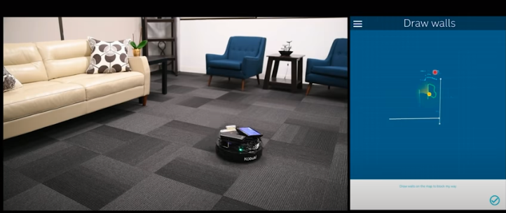
Hi Andrea Cecchetto Ac It looks as though the robot shown in that short video is the same one featured in Intel's longer 44 minute seminar about using D435 and T265 together.
https://www.youtube.com/watch?v=62vm0_RZ1nU
An image from that seminar is shown below:
Intel also published a guide on the subject of using D435 and T265 together:
https://dev.intelrealsense.com/docs/depth-and-tracking-cameras-alignment
There is an example program called rs-tracking-and-depth that the above guide discusses:
https://github.com/IntelRealSense/librealsense/tree/master/examples/tracking-and-depth
I believe that the mapping used in the demonstrated application is occupancy mapping. As far as I know, the application in the video has not been released to the public. Intel do have a ROS package for doing occupancy mapping though.
As this forum does not handle T265 related technical questions, I recommend posting further questions at the RealSense GitHub forum by visiting the link below and clicking on the New Issue button.
Please sign in to leave a comment.
Comments
1 comment